
Stream Fishing Along The Beartooth All-American Road
and the Chief Joseph Highway
by Gary Rafferty
The headwaters of the only Wild and Scenic river in Wyoming, comprise some of the most spectacular real estate in the lower 48 states. To access excellent small stream fishing for trout, travel east from Cooke City, MT … south from Red Lodge, MT … or north from Cody, WY.
U.S. Hwy 212, also known as the “Beartooth Pass All-American Road” runs east from Cooke City to Beartooth Pass, and then south to the Montana/Wyoming border and the headwaters of Rock Creek. Other fishing adventures can be found along Wyoming Hwy 296, know as the Chief Joseph Scenic Highway, which was named in honor of the famed Nez Perce Indian chief.
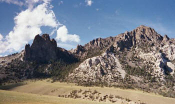 |
Just One of the Many Natural Wonders Along Hwy 296 |
The Upper Clark’s Fork of the Yellowstone River
Outside the northeast entrance to Yellowstone National Park and close to Cooke City (Montana), the upper Clark’s Fork of the Yellowstone River springs from the high mountain peaks close to the Montana/Wyoming border at the western end of the All-American Road. It then flows downstream into Wyoming. A notable western freestone stream, the Clark’s Fork is easily accessible from several pullouts and campgrounds, but the best fishing is always available to those willing to hike a little. The upper river parallels Hwy 212 and then Hwy 296 for 17 breathtaking miles. This stretch starts small, only 12 to 15 feet across, but doubles in size with the additions of Gilbert, Crazy and Lake Creeks.
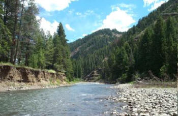 |
Upper Clarks Fork – Backcountry |
Fishermen enjoy relatively easy access to this high mountain gem at various pull-offs. I like to park at the Fox Creek or Crazy Creek campgrounds (along Hwy 212), and hike up or down stream as far as my water supply, my legs, or the weather will allow. If you want to fish larger and more moderately sloped water, park at the Lake Creek or Hunter Peak campgrounds further downstream along Hwy 296. The catch of the day could be wild brook, rainbow, or cutthroat trout. If you visit, look for photo opportunities along this stretch of river, as the famous Pilot and Index Peaks loom over the area. You may also see Rocky Mountain wildlife “up close and personal.” One brisk and cloudy September day I saw bear tracks and scat, watched a bald eagle hovering overhead, and got a quick glimpse of a mama moose and her calf crossing one of the small tributaries. The fishing was an added bonus that day, as a size 10 foam caddis dry fly with a size 16 beadhead emerger dropper took lots of fish in the 6 – 15 inch range…with one even larger rainbow lost to a succession of long-distance leaps. I did have my bear spray “at the ready,” but (thank goodness) did not need it.
Crazy Creek Falls and Lake Creek Falls
Located just west of the Beartooth/Chief Joseph Scenic Highway intersection, northern Wyoming hosts a uniquely-named stream and waterfall. The name “Crazy Creek” is attributed to two theories. One theory is the creek travels in a rumbling and crazy zig-zag sort of way. However, legend tells of an Indian woman living in the Clarks Fork Valley who went crazy and dashed away into the mountains. Her body was found here later by members of her tribe. A well-maintained walking trail takes you up an incline to a viewing area less than a mile from the parking area. Though not a prime fishing destination, Crazy Creek does contain a modest population of pan-sized trout in its shorter runs and deeper pockets.
A stop at Lake Creek allows a view of the falls shortly after the creek leaves Lily Lake. Lake Creek then plunges and cascades through a narrow canyon on its way to the Clark’s Fork. The access road to this area is located 1 ½ miles east of the junction of Hwy 212 and Hwy 296. Like Crazy Creek, Lake Creek canyon contains a small population of trout, but the fishing improves for those willing to hike into the meadows a few miles to the east, upstream from Lily Lake. If you hike the meadows in late-June or early-July, you will get panoramic views of snow-capped vistas and peaks.
Beartooth Creek and Falls
At the southwestern end of Beartooth Lake (see article on Lakes of the Beartooth), the waters of Beartooth Creek flow out under the Hwy 212 bridge, over massive glacial boulders, and tumble towards the falls. Visible at a distance while heading east towards the lake on the Hwy 212 (about a mile west of the Beartooth Lake campground), Beartooth Falls beckons young and hardy fishermen to scramble down a very steep and rocky incline to the water, and then follow along the bouldered creek bed upstream to the bottom of the falls (or downstream) where the rewards are good numbers of fish that hide in the pools and pockets.
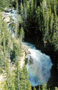 |
Beartooth Falls |
An easier hike starts at the Beartooth Lake outlet bridge and heads downstream to the top of the falls. But if you want to reach the base of the falls, it is still a tough descent down (with an even harder climb back to the lake). In late-summer or early-fall when water levels are low, the bravest of adventurers (who are not afraid of heights) can stand within the creek bed at the top of the falls and look downward. This is not for the faint-hearted! BTW, there is always a trout or two hiding out in the seams just below and above the outlet bridge. However, it takes cunning and near-perfect presentation to hook them so close to the road.
Little Known Little Waters
Other pan-fishing opportunities can be found at the inlet to Beartooth Lake, and the outlets of Island Lake and Little Bear Lake. If the weather is agreeable in the Spring (after ice out) and mild in October, the persistent fisherman could get into fast action for spawning trout in the inlet and outlets.
About 3 ½ miles east of the junction of Highways 212 and 296, the little known Muddy Creek crosses Hwy 212. The creek is fast and the canyon is steep. However, if you can make it down to the water, you will find pan-sized trout (and a few surprises) that have never seen a fly or a fisherman.
Rock Creek Montana
If you have the time, continue west and then north into Montana where Austrian-like canyons and valleys surround you along the headwaters of Rock Creek enroute to Red Lodge, MT. Featuring 47 fishable lakes and several fishable creeks, the Rock Creek drainage is a fisherman’s paradise from late June till the snow flies in Autumn. Though slightly steeper and more swift than the Upper Clarks Fork, Rock Creek has good public access and offers eager brook, rainbow and cutthroat trout ready to hit a well presented fly or lure. Don’t expect trophies here, but do expect lots of fish in the 6 to 11 inch range. The trout hang tight in short seams, pockets, runs and an occasional pool.
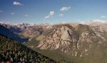 |
Majestic Rock Creek Valley |
As with the upper Clarks Fork and Beartooth Creek, all you need is a foam dry fly and a beadhead dropper to hook these fish. Use a short stout leader and tippet.
Closer to Red Lodge, anglers will find decent small stream fishing in the West Fork and the Lake Fork of Rock Creek. The key is to get behind the fish, and make short accurate casts into the slowest and deepest water can you find.
- Read an article on Fishing Beartooth Lakes